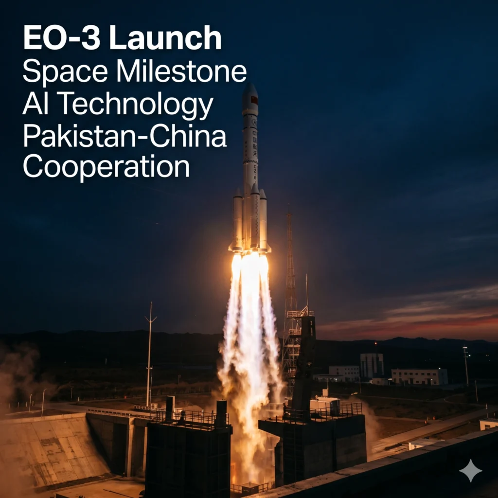
Pakistan EO-3 Satellite launch marks a monumental achievement for the nation’s burgeoning space program as SUPARCO continues its aggressive orbital expansion. This latest mission represents the third indigenous satellite deployed within a remarkably short sixteen-month window, signaling a rapid acceleration in Pakistan’s technical self-reliance. By integrating advanced electro-optical sensors with real-time artificial intelligence, the EO-3 system provides the country with unprecedented earth observation precision.
This launch, conducted from the Taiyuan Satellite Launch Centre, underscores the deepening strategic alliance between Islamabad and Beijing in the high-tech sector. As the global community monitors space developments, this milestone secures Pakistan’s position among emerging spacefaring nations capable of designing complex orbital hardware. The successful deployment of this asset ensures that national planners have access to high-resolution imagery for critical infrastructure and environmental monitoring.
Pakistan EO-3 Satellite Launch: A New Era for SUPARCO
The Pakistan EO-3 Satellite represents a significant leap forward in the country’s domestic manufacturing capabilities and orbital mission planning strategies. Following the successful deployment of its predecessors, this third unit integrates a sophisticated multi-geometry imaging module that enhances data depth. Engineers at the Pakistan Space and Upper Atmosphere Research Commission designed the hardware to withstand rigorous orbital conditions while maintaining high-speed communication links.
This mission was executed precisely at 8:15 pm Beijing time, utilizing the reliable Long March-6 carrier rocket to achieve the designated sun-synchronous orbit. Consequently, the satellite has already begun transmitting initial health signals to the ground control stations located within Pakistan. The integration of indigenous technology in the EO-3 platform reduces reliance on foreign satellite constellations for critical national data.
Furthermore, the strategic timing of this launch demonstrates the consistency of Pakistan’s space roadmap, which has seen three major successes since January 2025. Experts suggest that the rapid succession of these launches highlights a streamlined production line for indigenous satellite components. This progress is vital for maintaining a continuous stream of earth observation data for both civilian and governmental applications.
High-Tech AI Payloads Powering the Pakistan EO-3 Satellite
What distinguishes the Pakistan EO-3 Satellite from previous iterations is the inclusion of a dedicated onboard artificial intelligence processing unit. This AI module allows the satellite to perform real-time intelligent analysis of captured imagery before transmitting the data back to Earth. By processing information in orbit, the system significantly reduces the bandwidth required for downlinking and accelerates the decision-making process.
The AI-powered unit is specifically programmed to identify environmental changes, urban shifts, and potential disaster zones with minimal human intervention. Additionally, the satellite features an advanced energy storage system designed to support prolonged orbital operations and high-power imaging sessions. These technological advancements place Pakistan at the forefront of regional space innovation regarding smart satellite systems.
Moreover, the multi-geometry imaging module onboard provides a three-dimensional perspective of the earth’s surface, which is essential for accurate topographical mapping. This capability is particularly useful for mountainous regions where traditional 2D imaging often fails to capture essential elevation data. The synergy between AI and advanced optics ensures that the EO-3 remains a versatile tool for various scientific sectors.
Pakistan EO-3 Satellite Impact on Urban Planning and Security
The primary objective of the Pakistan EO-3 Satellite is to provide high-resolution data that will revolutionize how the nation manages its urban sprawl. As cities grow at an exponential rate, the need for accurate, real-time spatial data becomes a priority for municipal authorities. This satellite offers the granular detail necessary to monitor infrastructure development and land use patterns across all provinces.
In addition to urban management, the satellite plays a pivotal role in strengthening national food security through precision agriculture monitoring. By analyzing crop health and soil moisture levels from space, agricultural experts can provide better forecasts and interventions for farmers. This data-driven approach is expected to stabilize food supply chains and improve yield outcomes in the coming years.
From a security perspective, the satellite enhances the country’s border monitoring and maritime surveillance capabilities significantly. The ability to track movements and environmental changes in remote areas provides the state with a strategic advantage in managing its territories. Officials have noted that the socio-economic benefits of such a system far outweigh the initial investment in space technology.
Strategic Cooperation and the Success of Pakistan EO-3 Satellite
The deployment of the Pakistan EO-3 Satellite serves as a testament to the enduring strategic partnership between Pakistan and China in space exploration. China’s Taiyuan Satellite Launch Centre provided the sophisticated infrastructure needed for such a high-precision mission. This collaboration extends beyond just launch services, involving deep technical exchanges and shared research initiatives.
President Asif Ali Zardari and Prime Minister Shehbaz Sharif have both lauded the launch as a victory for the nation’s scientific community. They emphasized that the success of the EO-3 mission is a clear manifestation of Pakistan’s journey toward scientific self-reliance. This political support is crucial for ensuring continued funding and interest in future SUPARCO missions.
International observers view this launch as a sign of Pakistan’s maturing space ecosystem, which now includes robust design, testing, and operational phases. The partnership with China provides a reliable gateway to space while Pakistan focuses on developing the internal capacity to build complex payloads. This dual approach ensures both immediate results and long-term sustainability for the national space program.
Environmental Monitoring via the Pakistan EO-3 Satellite
Environmental protection is a core pillar of the Pakistan EO-3 Satellite mission, especially as the region faces increasing climate-related challenges. The satellite’s sensors are tuned to detect subtle changes in glacier melt, forest cover, and water levels in major reservoirs. This information is vital for developing early warning systems for floods and droughts that frequently impact the local population.
The multi-spectral imaging capabilities allow scientists to track air quality and industrial emissions with high precision across major industrial hubs. By providing a transparent view of the environment, the satellite helps the government enforce environmental regulations and meet international climate goals. The data is also shared with academic institutions to foster home-grown research in atmospheric sciences.
- Real-time flood risk assessment for the Indus River basin.
- Monitoring of deforestation and illegal land clearing in northern territories.
- Tracking of coastal erosion and Arabian Sea maritime conditions.
- Analysis of urban heat islands in rapidly expanding metropolitan areas.
Advancing Indigenous Space Technology in Pakistan
The development of the Pakistan EO-3 Satellite highlights the professional expertise of the engineers and scientists at SUPARCO. Building a satellite with indigenous components involves complex integration of thermal controls, power systems, and communication arrays. The success of this third mission proves that the initial successes of EO-1 and EO-2 were not isolated events but part of a sustainable trend.
The mission also serves as a laboratory for testing next-generation space technologies that will be used in future lunar or deep-space missions. Each successful deployment provides valuable telemetry data that helps refine the design of future satellite buses. This iterative process of learning and improving is the hallmark of a successful national space agency.
Moreover, the project has inspired a new generation of students and researchers to pursue careers in STEM fields across the country. The visibility of such high-profile missions creates a culture of innovation and pride in domestic technological achievements. As SUPARCO expands its fleet, the demand for local talent in aerospace engineering is expected to grow significantly.
Future Outlook for the Pakistan EO-3 Satellite Program
The operational life of the Pakistan EO-3 Satellite is expected to span several years, during which it will provide a continuous stream of data. This continuity is essential for longitudinal studies of the environment and long-term infrastructure projects. The integrated system of EO-1, EO-2, and now EO-3 creates a powerful constellation that increases the frequency of data collection over specific areas.
Future plans include the development of even higher resolution satellites and potentially synthetic aperture radar (SAR) systems for all-weather imaging. The success of the current electro-optical fleet provides the financial and political capital to pursue these more ambitious projects. Pakistan is clearly committed to maintaining a permanent and sophisticated presence in Earth orbit.
In conclusion, the successful launch of the EO-3 satellite is a defining moment for Pakistan’s technological landscape. It combines international cooperation with domestic ingenuity to solve real-world problems facing the nation. As the satellite settles into its orbit, the focus now shifts to the vast amounts of data it will generate to build a more resilient and informed society.
Technical Specifications of the Pakistan EO-3 Satellite
The technical prowess of the Pakistan EO-3 Satellite is rooted in its high-performance bus and payload architecture. It operates in a sun-synchronous orbit, which allows it to pass over the same locations at the same local solar time. This consistency is vital for comparing images taken weeks or months apart to detect changes in the landscape.
Equipped with high-resolution telescopes, the satellite can distinguish between different types of vegetation and man-made structures with ease. The communication system utilizes high-frequency bands to ensure that large volumes of imaging data are transmitted without loss. These specifications ensure that Pakistan remains competitive in the regional market for satellite services and data.
- Onboard AI data processing for real-time intelligent analysis.
- High-efficiency solar arrays for constant power generation.
- Multi-geometry sensors for detailed topographic and urban mapping.
- Advanced propulsion systems for precise orbital maintenance and maneuvers.
Economic Benefits of the Pakistan EO-3 Satellite
Investing in the Pakistan EO-3 Satellite yields significant economic returns by providing data that was previously purchased from international vendors. By owning the data source, the government can provide free or low-cost imagery to local startups and research firms. This stimulates the local geospatial industry and encourages the development of new applications for satellite data.
Furthermore, the satellite helps in the efficient planning of mega-projects like the China-Pakistan Economic Corridor (CPEC) by providing up-to-date site surveys. This reduces the time and cost associated with ground-based mapping and allows for better risk assessment during the construction phase. The economic ripple effects of a successful space program are visible across multiple sectors of the national economy.
- Reduction in foreign exchange spending on satellite imagery products.
- Support for the local tech ecosystem through open-access data initiatives.
- Enhanced efficiency in large-scale infrastructure and energy projects.
- Improved disaster response which saves billions in potential economic losses.
Global Recognition of the Pakistan EO-3 Satellite Mission
The international community has taken note of the Pakistan EO-3 Satellite launch, recognizing it as a sign of a stabilizing and advancing scientific sector. Peer space agencies have congratulated SUPARCO on the rapid deployment of its Earth observation fleet. This recognition opens doors for future international collaborations and participation in global space exploration forums.
By demonstrating the ability to manage complex space missions, Pakistan strengthens its diplomatic standing in the realm of science and technology. The transparency of the mission and the focus on socio-economic benefits have been praised by global environmental organizations. The EO-3 satellite is not just a national asset but a contributor to the global understanding of our planet’s changing climate.
As Pakistan continues to share its findings with the global scientific community, it builds a reputation as a responsible and capable space actor. This mission proves that even in challenging economic times, a focused investment in technology can yield historic results. The legacy of the EO-3 mission will be measured by the lives improved through the data it provides from the silent reaches of space.
Pakistan EO-3 Satellite and Disaster Management Protocols
One of the most critical roles for the Pakistan EO-3 Satellite is its integration into the national disaster management framework. During monsoon seasons, the satellite provides daily updates on cloud formations and river levels, allowing for timely evacuations. The AI-powered analysis can predict potential landslide zones in the northern areas before they occur, saving countless lives.
In the aftermath of an earthquake or flood, the satellite provides the “first look” at the affected areas, helping rescue teams prioritize their efforts. This rapid response capability is a major upgrade from previous years when the country had to wait for international satellites to pass over the region. The EO-3 satellite ensures that Pakistan is never blind during a national crisis.
- Rapid damage assessment following natural disasters and extreme weather.
- Early warning signals for drought conditions in arid provinces.
- Monitoring of locust movements to protect national agricultural output.
- Post-disaster reconstruction tracking to ensure transparency and speed.
Strategic Significance of the Pakistan EO-3 Satellite
The strategic significance of the Pakistan EO-3 Satellite extends to its role in regional stability and technological independence. By having a dedicated eye in the sky, Pakistan can independently verify ground realities without relying on third-party narratives. This autonomy is essential for a sovereign nation in the modern digital age where information is power.
The satellite also serves as a platform for testing encrypted communication technologies that are vital for national security. As the space domain becomes increasingly congested, the ability to operate independently becomes a key pillar of national defense. The EO-3 mission is a clear signal that Pakistan intends to protect its interests in the final frontier.
Ultimately, the Pakistan EO-3 Satellite is a symbol of national pride and a beacon of what is possible through dedication and expertise. It bridges the gap between traditional governance and modern, data-driven administration. As the satellite continues its journey around the globe, it carries with it the aspirations of a nation looking toward a brighter, more advanced future.
For more details & sources visit: Dawn
Read more about Pakistan news on 360 News Orbit – Pakistan.