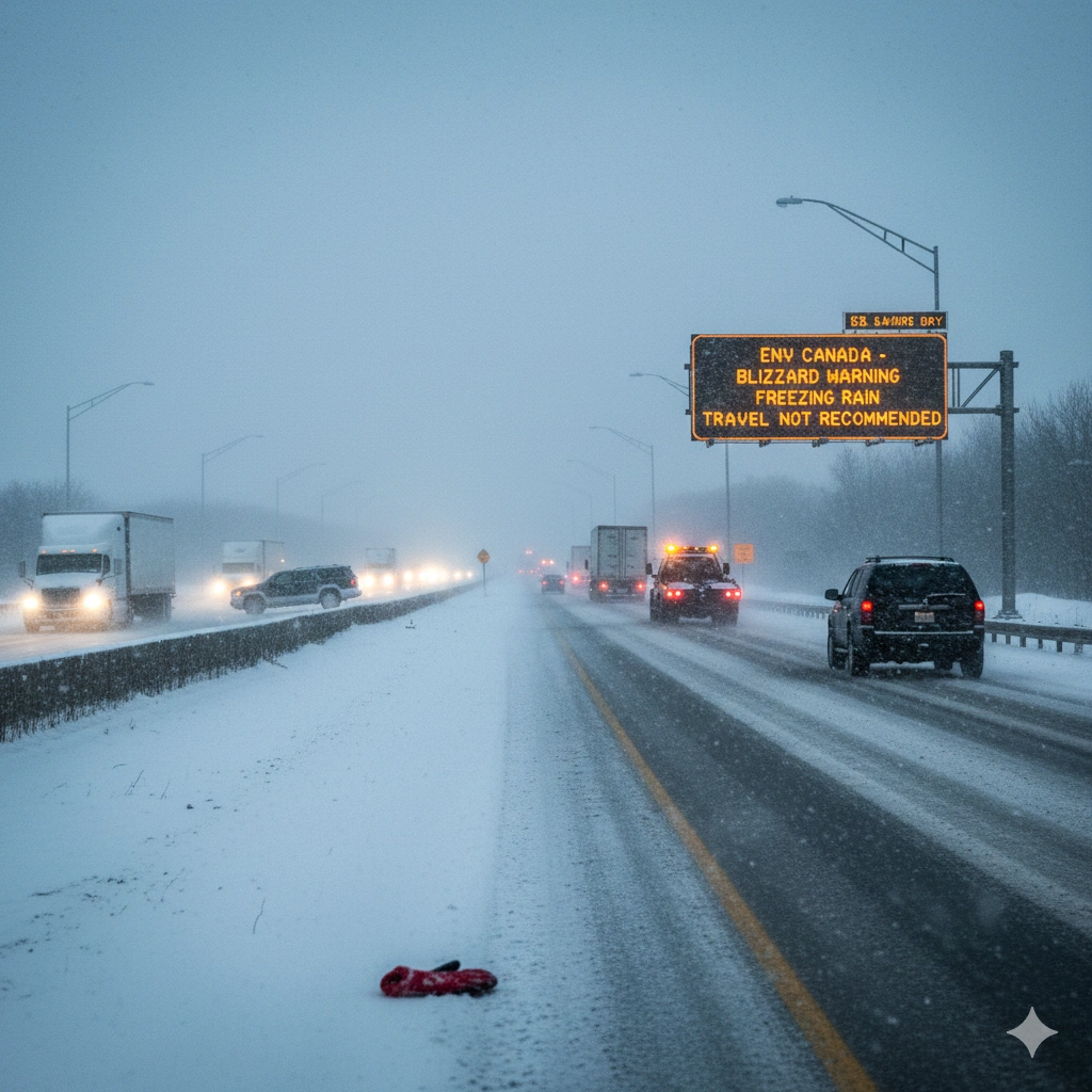
A yellow warning has been issued across parts of southern Ontario as snowfall and freezing rain warnings come into effect with a winter system impacting the region on December 26, 2025, according to Environment Canada.
The alert warns of deteriorating travel conditions as snow intensifies and visibility drops in several areas throughout the day. Officials note that snowfall rates may vary by location, with some communities experiencing brief but intense bursts of snow that could quickly reduce visibility and create slippery road surfaces, especially during peak travel hours.
Environment Canada Places Regions Under Yellow Warning
Environment Canada confirmed that multiple parts of southern Ontario are now under a yellow warning due to the expected combination of snowfall and freezing rain. Snow is forecast to begin in the morning hours and continue into the afternoon before tapering off later in the day.
Weather officials explained that fluctuating snowfall intensity could lead to rapidly changing conditions, where roads that appear clear at one moment may become snow-covered within a short time. This pattern increases the risk of sudden slowdowns and minor collisions, particularly on untreated routes and secondary roads. Officials cautioned that visibility may be reduced during peak snowfall periods, increasing risks for motorists and pedestrians.
Snowfall and Freezing Rain Warning for Toronto and GTA
Under the current snowfall and freezing rain warning, Toronto and the Greater Toronto Area could receive between 8 and 12 centimetres of snow as the winter system moves through.
Forecasters noted that heavier bursts of snow are possible during the afternoon, which may further affect road conditions and commute times. These bursts could coincide with busy travel periods, leading to congestion on major highways, delays in public transit services, and slower movement through city streets. Snow accumulation on sidewalks may also pose challenges for pedestrians in urban areas. Drivers are advised to remain alert and adjust travel plans if necessary.
Storm Track Uncertainty Remains
Meteorologists also highlighted uncertainty around the storm’s track, which could influence where the heaviest snowfall occurs. A slight eastward shift could result in higher accumulations in some areas, while others may see reduced totals.
A slight eastward shift could result in higher accumulations in some areas, while others may see reduced totals. Forecasting models suggest that even minor changes in the storm’s path could significantly alter snowfall distribution, making it difficult to pinpoint exact accumulation amounts. As a result, some regions may experience conditions that differ from earlier projections. Because of this uncertainty, residents are encouraged to monitor updated forecasts throughout the day.
Northern Ontario Facing Higher Snow Accumulations
While southern Ontario remains under a yellow warning, northern regions are expected to see heavier snowfall. Areas from Sault Ste. Marie toward regions near Thunder Bay could receive up to 20 centimetres of snow. Areas from Sault Ste. Marie toward regions near Thunder Bay could receive up to 20 centimetres of snow, with snowfall persisting for longer periods compared to the south.
Colder temperatures in these regions may prevent melting, allowing snow to accumulate more quickly and remain on road surfaces, increasing the likelihood of difficult driving conditions. These conditions may lead to hazardous travel, particularly on highways and rural roads.
Travel Caution Urged as Conditions Worsen
Environment Canada is urging both drivers and pedestrians to exercise caution as conditions deteriorate. Snow-covered roads, icy surfaces, and reduced visibility may create dangerous situations, especially during busy travel periods.
Snow-covered roads, icy surfaces, and reduced visibility may create dangerous situations, especially during busy travel periods. Authorities advise motorists to reduce speeds, maintain greater following distances, and ensure vehicles are equipped with winter tires. Pedestrians are also encouraged to wear proper footwear and remain cautious on untreated walkways.
Weather Outlook for December 26
As the winter system continues to move through Ontario, the yellow warning and snowfall and freezing rain warning remain in effect for much of the day. Snowfall is expected to ease later, though icy conditions may persist into the evening.
Snowfall is expected to ease later, though icy patches may linger into the evening, particularly on bridges, overpasses, and less-traveled roads. Officials note that even after snowfall ends, lingering cold temperatures could prolong hazardous conditions overnight.
For more details & sources visit: Global News
For more updates and related stories, visit our Canada News page.