The Antarctica hidden landscape map has revealed the most detailed view yet of the continent’s terrain beneath its ice sheets. Scientists behind Bedmap3 uncovered mountains, deep canyons, and hidden subglacial waterways, offering essential insights into ice flow and potential sea-level impacts as the climate warms.
Containing roughly 27 million cubic kilometers of ice, Antarctica holds enough water to raise global sea levels by 58 meters if fully melted. Understanding the underlying terrain is therefore critical for predicting ice movement, modeling climate change, and preparing for future environmental shifts.
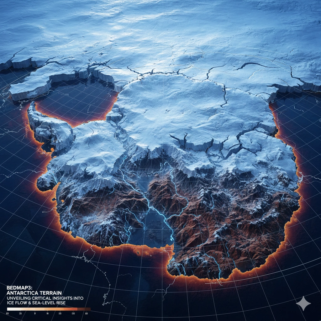
Bedmap3: 52 Million Data Points Shape the Hidden Landscape
The Antarctica hidden landscape map is the product of over six decades of research, integrating 52 million data points from satellites, ships, aerial surveys, and dog-sled expeditions. Researchers conducted 84 new surveys to fill gaps and used advanced modeling to reveal intricate subglacial features like troughs and mountain ranges.
This comprehensive mapping allows scientists to see how the ice sheet interacts with the underlying topography, crucial for predicting where ice may accelerate toward the ocean and which regions are most vulnerable to melting.
Subglacial Mountains, Valleys, and Waterways
Bedmap3 exposes previously hidden features, including massive subglacial mountain ranges, deep canyons, and flowing sub-ice rivers. These features control ice movement, acting as natural channels or barriers. Understanding them is key to anticipating regional melting patterns and identifying potential hotspots of ice loss.
By including these features in climate models, scientists can make more accurate predictions about Antarctic ice behavior, giving policymakers better tools to plan for rising seas and global climate impacts. The detailed topography also helps researchers understand how subglacial water systems interact with ice sheets, influencing sliding rates and ice shelf stability. This information is crucial for identifying regions that may experience accelerated ice discharge, which could significantly affect coastal communities and global sea-level rise over the coming decades.
Ice Flow and Climate Implications
The new map shows that ice flow is heavily influenced by subglacial topography. Valleys and troughs accelerate ice toward the ocean, while mountains slow it down. By modeling these dynamics, the Antarctica hidden landscape map provides insight into how ice sheets respond to warming temperatures, including potential future sea-level rise scenarios.
This knowledge is critical for predicting coastal flooding worldwide and understanding how Antarctic ice contributes to global climate change. Additionally, it allows scientists to simulate how ice sheets may react to extreme weather events, ocean warming, and glacial melting. Understanding these processes can help prioritize monitoring and research efforts in the most vulnerable regions, guiding mitigation strategies and informing international policy decisions on climate adaptation.
Why Bedmap3 is a Milestone
Bedmap3 is the most detailed map of Antarctica to date, far surpassing previous versions in both resolution and accuracy. By combining historical surveys with cutting-edge satellite data, the map gives researchers a comprehensive view of the hidden landscape, serving as a foundation for future polar research, ice monitoring, and climate modeling.
The significance of Bedmap3 goes beyond mapping; it provides a baseline for long-term studies of ice sheet stability, helping scientists track changes over time. It also enables improved integration of Antarctic topography into global climate and sea-level rise models, which is essential for anticipating future environmental shifts. By revealing hidden features like subglacial valleys and waterways, Bedmap3 opens new avenues for studying ice dynamics, glacial history, and subglacial ecosystems, making it a transformative tool in polar science.
Future Applications of the Antarctica Hidden Landscape Map
The Antarctica hidden landscape map 2025 will guide:
- Climate model refinement for better sea-level projections.
- Identification of regions at risk of rapid ice loss.
- Planning for scientific expeditions and satellite missions.
- Long-term monitoring of ice dynamics in a warming world.
By providing unprecedented detail, Bedmap3 enhances our understanding of Antarctica’s role in the global climate system.
Looking Ahead
The unveiling of the Antarctica hidden landscape map marks a major milestone in Earth science. With mountains, valleys, and subglacial waterways revealed beneath 27 million cubic kilometers of ice, scientists now have the tools to predict ice sheet behavior more accurately and prepare for climate-related challenges worldwide.
For more details & sources visit: ZME Science
Read more on Antarctica news: 360 News Orbit – Antarctica