Antarctic ice retreat is a critical indicator of global climate stability that scientists are monitoring with increasing precision through satellite technology. Recent data indicates that while large portions of the frozen continent remain relatively stable, specific regions are experiencing rapid transformations. This 30-year longitudinal study provides a comprehensive map of how the grounding lines—the boundary where ice leaves the land and begins to float—are shifting in response to environmental pressures. By analyzing decades of radar measurements, researchers can now pinpoint exactly where the ice is thinning and where the risks of significant sea-level rise are most acute.
Understanding the dynamics of Antarctic ice retreat requires a deep dive into the geographical nuances of the Southern Ocean and its interaction with the ice sheet. While seventy-seven percent of the coastline has shown remarkable resilience, the remaining areas tell a story of dramatic change. This dichotomy between stability and rapid loss highlights the complexity of polar systems. Furthermore, the use of advanced satellite interferometry has allowed for a level of detail previously thought impossible. These findings are not merely academic but serve as a foundational element for future global climate policy and coastal management strategies.
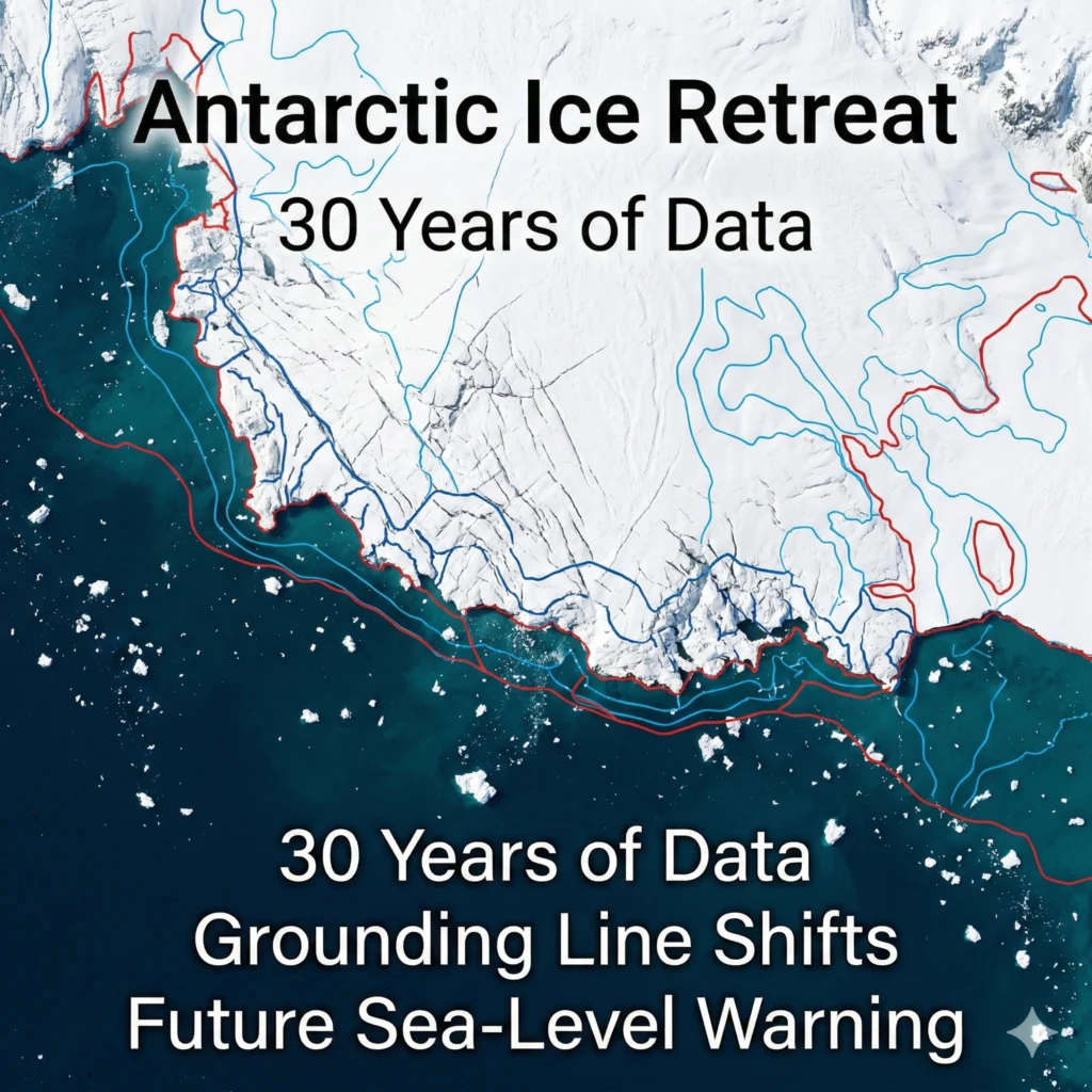
Antarctic Ice Retreat
The phenomenon of Antarctic ice retreat is most visible along the Amundsen Sea coast, where the grounding lines have moved inland at an alarming rate. According to the latest satellite data, some glaciers have retreated by as much as forty-two kilometers over the last three decades. This movement is a direct result of warming ocean currents reaching the deep glacier beds through complex underwater channels. When warm water makes contact with the base of the ice, it accelerates the melting process from beneath, causing the ice to detach from the bedrock and flow more quickly into the sea.
The bedrock topography plays a significant role in how Antarctic ice retreat progresses across different sectors. In many vulnerable regions of West Antarctica, the bedrock actually slopes downward as it moves further inland, creating a “marine ice sheet instability.” This means that once the retreat begins, it can become a self-sustaining process that is difficult to reverse. Consequently, the Pine Island and Thwaites glaciers have become primary points of concern for the international scientific community. Their rapid thinning contributes significantly to the total volume of ice being lost to the ocean each year.
Satellite observations have confirmed that the total area of grounded ice lost between 1996 and 2025 is approximately 12,800 square kilometers. This massive figure illustrates the scale of Antarctic ice retreat when viewed over a multi-decadal period. While the East Antarctic Ice Sheet remains largely intact and stable, the imbalances in the West are enough to influence global sea levels. Researchers emphasize that the precision of these measurements, down to a few millimeters of vertical movement, is essential for building accurate models. Without this level of detail, predicting the timing of future collapses would be largely guesswork.
Historical Context of Polar Monitoring
The history of monitoring Antarctic ice retreat is deeply intertwined with the evolution of space-borne radar technology. In the early 1990s, the first European Remote-Sensing satellites began providing the baseline data needed to understand the continent’s fringes. Over time, the addition of the Copernicus Sentinel-1 mission has drastically increased the frequency and resolution of these observations. This long-term data record allows scientists to distinguish between short-term seasonal fluctuations and the long-term trends associated with climate change. It is this historical perspective that confirms the current retreat is an anomaly compared to previous centuries.
International cooperation has been the backbone of tracking Antarctic ice retreat throughout the twenty-first century. Agencies like the European Space Agency and NASA have shared resources and data to ensure a continuous “eye in the sky” over the South Pole. This synergy is vital because the Antarctic environment is too vast and hostile for ground-based measurements alone. By combining different types of satellite data, such as gravimetry and altimetry, scientists can verify the grounding line positions with high confidence. This collaborative approach ensures that the global community has access to the most reliable information regarding polar health.
The transition from visual photography to synthetic aperture radar (SAR) changed the way we view Antarctic ice retreat. Unlike optical cameras, SAR can see through clouds and operate during the long months of polar darkness. This capability is crucial for capturing the winter dynamics of the ice sheet when some of the most significant structural changes occur. The ability to monitor the continent year-round has revealed that melting is not just a summer phenomenon. Sub-shelf melting continues throughout the year, driven by deep-ocean heat that remains trapped beneath the surface.
Role of Grounding Lines in Stability
Grounding lines are the front lines of the battle against Antarctic ice retreat, acting as a physical brake for the glaciers behind them. When a grounding line is pushed back, the friction between the ice and the rock is reduced, allowing the glacier to flow faster. This creates a feedback loop where faster flow leads to more thinning, which in turn leads to further retreat. Mapping these lines with millimeter precision allows researchers to identify which glaciers are on the verge of a “runaway” retreat scenario. These boundaries are the most sensitive indicators of whether an ice sheet is in balance or in decline.
The stability of the Ross and Amery ice shelves provides a stark contrast to the rapid Antarctic ice retreat seen elsewhere. These massive floating platforms act as buttresses, holding back the vast reservoirs of ice in East Antarctica. As long as these grounding lines remain stationary, the interior of the continent remains relatively protected from the warming ocean. However, the study warns that even these stable regions must be monitored closely, as underwater “basins” could allow warm water to penetrate deep into the interior if the outer defenses are breached. Stability in one area does not guarantee immunity for the whole continent.
Measuring the vertical movement of ice caused by tides is a key technique for identifying the exact location of a grounding line. As the tide rises and falls, the floating portion of the ice moves with it, while the grounded portion remains stationary. This “flexure zone” is where Antarctic ice retreat is most accurately measured using differential interferometry. By observing these subtle shifts from space, scientists can map the transition zone with incredible accuracy. This data is then fed into climate models to improve our understanding of how the ice sheet will respond to further atmospheric and oceanic warming.
Vulnerable Regions of West Antarctica
The West Getz and Smith ice sheets are currently centers of intense Antarctic ice retreat activity. These areas have seen significant thinning over the last decade, primarily due to the influx of Circumpolar Deep Water. This relatively warm, salty water mass is being pushed onto the continental shelf by changing wind patterns. Once it reaches the cavities beneath the ice shelves, it eats away at the “keels” of the glaciers. This process is largely invisible from the surface but has devastating consequences for the overall structural integrity of the ice sheet.
Thwaites Glacier, often dubbed the “Doomsday Glacier,” is perhaps the most famous example of Antarctic ice retreat in action. Its grounding line is retreating into a deep basin that could eventually lead to the collapse of a significant portion of the West Antarctic Ice Sheet. The current study reinforces the urgency of monitoring Thwaites, as its contribution to sea-level rise is already measurable. If the retreat continues at its current pace, the resulting sea-level rise could threaten coastal cities across the globe. The satellite data provides a sobering look at the physical reality of this melting giant.
- The Amundsen Sea Embayment shows the fastest rates of ice loss.
- Glacial thinning is occurring even in areas previously thought to be stable.
- Sub-glacial channels act as highways for warm ocean water.
- Bedrock depth influences the speed of the grounding line withdrawal.
Pine Island Glacier is another critical site where Antarctic ice retreat is being closely tracked. Over the past thirty years, it has lost a substantial amount of grounded ice, leading to an increase in the speed of its ice flow. This glacier acts as a primary drainage pipe for the interior ice, and its acceleration means more ice is being dumped into the ocean than is being replaced by snowfall. The study highlights that the retreat at Pine Island is not a linear process; it often occurs in pulses following specific oceanographic events. Understanding these pulses is key to predicting future changes.
Mechanisms of Accelerated Melting
The primary driver behind the observed Antarctic ice retreat is the interaction between the ice and the warming Southern Ocean. As global temperatures rise, the winds that circle Antarctica are changing in strength and position. these changes are driving warmer water from the deep ocean up onto the shallow continental shelves. Once this water reaches the grounding line, it melts the ice at a rate much higher than atmospheric warming alone could achieve. This ocean-driven melting is the “silent killer” of the Antarctic ice shelves, working from the bottom up.
Sub-glacial hydrology also plays a surprising role in the story of Antarctic ice retreat. Meltwater at the base of a glacier can act as a lubricant, allowing the ice to slide more easily over the bedrock. This water often collects in vast sub-glacial lakes and then drains into the ocean through hidden river systems. When these rivers discharge at the grounding line, they create turbulence that brings even more warm ocean water into contact with the ice. This complex interplay between freshwater and saltwater is a major focus of current polar research.
- Enhanced thermal exchange at the ice-ocean interface.
- Increased basal sliding due to sub-glacial meltwater.
- Loss of buttressing force from floating ice shelves.
- Structural fracturing of ice cliffs after grounding line retreat.
The geometric configuration of the ice shelf cavities also influences the rate of Antarctic ice retreat. In some areas, the shape of the seafloor creates “pinning points” that help hold the ice in place. However, as the ice thins, it can lift off these pinning points, leading to a sudden and rapid acceleration of the glacier. The study utilized high-resolution satellite radar to identify these subtle changes in contact, providing a clearer picture of why some glaciers retreat faster than others. This structural insight is essential for determining the “tipping points” of the Antarctic ice sheet.
Stability of the East Antarctic Coastline
In contrast to the West, much of the East Antarctic coastline has shown a surprising level of stability regarding Antarctic ice retreat. The Amery and Ross ice shelves, for example, have maintained their grounding line positions for decades. This stability is largely due to the colder ocean conditions in the East and a bedrock topography that is generally higher than sea level. While these regions are not currently contributing significantly to sea-level rise, they contain enough ice to raise global sea levels by dozens of meters if they were to melt. Therefore, their continued stability is of paramount importance.
However, the study notes that even in the East, there are signs that Antarctic ice retreat could begin in specific sectors. The Wilkes Land region, for instance, has several glaciers that are grounded below sea level in deep basins. While they are currently protected by a fringe of sea ice and cold water, they remain a “sleeping giant” in the climate system. Any significant shift in ocean currents could bring warm water to these sectors, potentially triggering a retreat similar to what we see in the West. Vigilance remains the watchword for polar scientists monitoring these massive ice stores.
- Ross Ice Shelf remains the most stable large-scale feature.
- Amery Ice Shelf shows minimal grounding line migration.
- Colder surrounding waters protect the East Antarctic fringe.
- Topographic barriers prevent easy access for warm deep water.
The role of snowfall in offsetting Antarctic ice retreat is also more pronounced in the East. As the atmosphere warms, it can hold more moisture, which often falls as snow over the vast interior of the continent. In some areas of East Antarctica, this accumulation of snow is actually causing the ice sheet to thicken slightly. However, researchers are quick to point out that this gain in mass is currently not enough to offset the massive losses occurring in the West. The net balance of the continent remains negative, meaning more ice is being lost than gained.
Implications for Global Sea-Level Rise
The most direct consequence of Antarctic ice retreat is the inevitable rise in global sea levels. As grounded ice moves into the ocean and begins to float, it displaces a volume of water equal to its mass. The 12,800 square kilometers of ice lost over the last thirty years represents a significant volume of water added to the world’s oceans. If the retreat in the Amundsen Sea continues at its current pace, we can expect a measurable increase in coastal flooding events worldwide. This makes polar science a matter of immediate concern for urban planners and coastal residents.
Future projections of sea-level rise are heavily dependent on the data gathered regarding Antarctic ice retreat. By refining our understanding of how grounding lines move, we can create more accurate simulations of how the ice sheet will look in fifty or one hundred years. These models are the basis for international climate agreements and adaptation strategies. The study led by the University of California, Irvine, provides the high-fidelity data needed to reduce the uncertainty in these projections. Knowing whether sea levels will rise by thirty centimeters or one meter by the end of the century is a distinction of trillion-dollar importance.
- Increased frequency of high-tide flooding in coastal cities.
- Saltwater intrusion into freshwater aquifers and estuaries.
- Loss of critical coastal habitats and biodiversity.
- Heightened risk of storm surge damage during extreme weather.
The social and economic impacts of Antarctic ice retreat extend far beyond the polar regions. Displacement of populations in low-lying areas like Bangladesh, Florida, and the Netherlands is a looming reality if the West Antarctic Ice Sheet continues its decline. The cost of building sea walls and moving infrastructure is staggering, which is why early warning systems provided by satellite data are so valuable. By understanding the pace of the retreat today, we can better prepare for the environment of tomorrow. The data is a call to action for both mitigation of carbon emissions and investment in resilient infrastructure.
Technological Advances in Satellite Radar
The success of this comprehensive study on Antarctic ice retreat is a testament to the power of modern radar technology. Differential Interferometric Synthetic Aperture Radar (DInSAR) is the specific technique that allows scientists to detect microscopic changes in ice elevation. By comparing two radar images of the same area taken at different times, researchers can create an “interferogram” that shows the movement of the ice. This technology is sensitive enough to detect the vertical “breathing” of the ice sheet as it responds to the tides, which is the key to finding the grounding line.
Continuous Earth observation missions are essential for tracking the long-term trends of Antarctic ice retreat. The European Space Agency’s Sentinel-1 constellation provides a reliable stream of data that is freely available to researchers worldwide. This open-data policy has democratized polar science, allowing experts from across the globe to contribute to our understanding of the ice sheet. The high temporal frequency of these satellites—capturing images every few days—means that sudden calving events or rapid shifts in flow speed are never missed. This persistent surveillance is our best defense against environmental surprises.
The future of monitoring Antarctic ice retreat looks even more promising with the upcoming launch of new satellite missions. Future sensors will use different radar frequencies to “see” deeper into the ice and provide even more detail on the internal structure of glaciers. These advancements will allow scientists to map the sub-glacial water systems and bedrock characteristics with unprecedented clarity. As our technological eyes in the sky become more sharp, our ability to predict the future of the Antarctic continent will only improve. This ongoing investment in space technology is a vital component of global climate research.
Conclusion and Future Projections
The findings of this thirty-year study on Antarctic ice retreat offer a sobering reminder of the sensitivity of our planet’s polar regions. While much of the continent remains stable for now, the rapid changes in West Antarctica are a clear signal of an environment under stress. The loss of nearly half the size of Belgium in grounded ice area is a wake-up call regarding the scale of the transformation currently underway. Satellite data has moved us past the era of speculation and into an era of precise, quantifiable observation.
Moving forward, the focus will remain on the high-risk sectors of the Amundsen Sea. Tracking the Antarctic ice retreat in these areas will be critical for updating sea-level rise estimates in the next IPCC reports. Scientists emphasize that while some of this retreat may be “locked in,” our actions to reduce global warming can still influence the speed and ultimate extent of the ice loss. The data serves as both a scientific record and a roadmap for the challenges that lie ahead in the 21st century.
For more details & sources visit: European Space Agency
Read more on Antarctica news: 360 News Orbit – Antarctica.